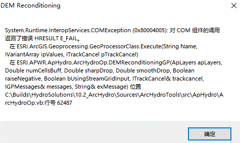
运行fill sinks时出现报错信息
System.runtime.interopservices.comexception (0x80004005): error hresult e_fail

查阅相关问题之后,得到以下解决方案:
I moved all of my data under C:\data\
I created new file geodatabase (named testing.gdb) under that folder
I increased the max number of unique values to render
I set out the targets (C:\data for raster and C:\data\testing.gdb for vector files) using ApUtilites
I set out the processing extent to the extent of my DEM (Geoprocessings>Environments>Processing extent ) )
I saved my project as testing.mxd under C:\data
I set testing.gdb to be default workspace. (this finally solved the last errors I was getting)
I also named my data frame simply to "data" since ArcHydro -tools tend to add data frame name to output-file paths. I'm not sure if step this is needed.
出处 链接
简单翻译:
我将所有数据移动到 C:\data\
我在该文件夹下创建了新文件地理数据库(名为 testing.gdb)
我增加了要呈现的唯一值的最大数量
我设置了目标(C:\data 用于栅格和 C :\data\testing.gdb 用于矢量文件)使用 ApUtilites
我将处理范围设置为我的 DEM(地理处理>环境>处理范围))
我将我的项目保存为 testing.mxd 在 C:\data
我设置测试.gdb 为默认工作区。(这最终解决了我遇到的最后一个错误)
我还将我的数据框简单地命名为“数据”,因为 ArcHydro 工具倾向于将数据框名称添加到输出文件路径。我不确定是否需要这一步。
按照建议修改后,均未解决问题。
遂选择toolbox内的fill sinks尝试运行,以获得更详细的报错说明
果不其然,运行失败,但是报错直指问题所在
Configuration RasterCommander.ImageServer can not be started
这种报错之前遇到过,只要将并行计算参数设置为0即可解决。
具体修改步骤如下:
在工具栏中,找到“Geoprocessing”,选择下方“Environments…”选项。
找到“Parallel Processing”选项,并将其Factor设置为0。
随后再次执行对应操作,即可不报错成功执行操作。